| News / Science News |
Arctic Sea Ice Annual Minimum Ties Second Lowest on Record
NASA | SEPTEMBER 15, 2016
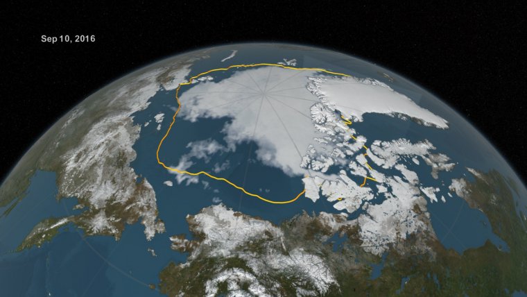
An analysis of satellite data showed that at 1.60 million square miles (4.14 million square kilometers), the 2016 Arctic sea ice minimum extent is effectively tied with 2007 for the second lowest yearly minimum in the satellite record. Since satellites began monitoring sea ice in 1978, researchers have observed a steep decline in the average extent of Arctic sea ice for every month of the year.

The 2016 Arctic sea ice summertime minimum, reached on Sept. 10, is 911,000 square miles below the 1981-2010 average minimum sea ice extent, shown here as a gold line. ![]()
The sea ice cover of the Arctic Ocean and surrounding seas helps regulate the planet’s temperature, influences the circulation of the atmosphere and ocean, and impacts Arctic communities and ecosystems.
Arctic sea ice shrinks every year during the spring and summer until it reaches its minimum yearly extent. Sea ice regrows during the frigid fall and winter months, when the sun is below the horizon in the Arctic.
This summer, the melt of Arctic sea ice surprised scientists by changing pace several times. The melt season began with a record low yearly maximum extent in March and a rapid ice loss through May.
But in June and July, low atmospheric pressures and cloudy skies slowed down the melt. Then, after two large storms went across the Arctic basin in August, sea ice melt picked up speed through early September.
Arctic sea ice cover has not fared well during other months of the year either.
A recently published study that ranked 37 years of monthly sea ice extents in the Arctic and Antarctic found that there has not been a record high in Arctic sea ice extents in any month since 1986. During that same time period, there have been 75 new record lows.
YOU MAY ALSO LIKE


