| News / Space News |
NASA Finds Possible Second Impact Crater Under Greenland Ice
A NASA glaciologist has discovered a possible second impact crater buried under more than a mile of ice in northwest Greenland.

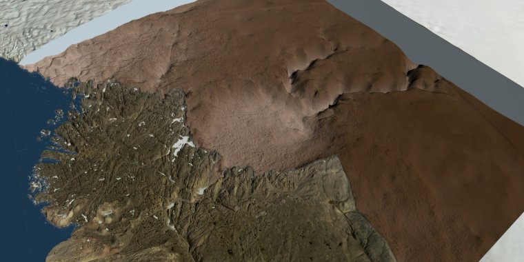
A still image showing the ice sheet removed in the region around the Hiawatha Glacier. The bed topography under the ice clearly shows the Hiawatha crater. Photo: NASA
This follows the finding of a 19-mile-wide crater beneath Hiawatha Glacier – the first meteorite impact crater ever discovered under Earth’s ice sheets.
If the second crater, which has a width of over 22 miles, is ultimately confirmed as the result of a meteorite impact, it will be the 22nd largest impact crater found on Earth.
Before the discovery of the Hiawatha impact crater, scientists generally assumed that most evidence of past impacts in Greenland and Antarctica would have been wiped away by unrelenting erosion by the overlying ice.
Following the finding of that first crater, Joe MacGregor, a glaciologist with NASA’s Goddard Space Flight Center, checked topographic maps of the rock beneath Greenland’s ice for signs of other craters.
Using imagery of the ice surface from the Moderate Resolution Imaging Spectroradiometer instruments aboard NASA’s Terra and Aqua satellites, he soon noticed a circular pattern some 114 miles to the southeast of Hiawatha Glacier. The same circular pattern also showed up in ArcticDEM, a high-resolution digital elevation model of the entire Arctic derived from commercial satellite imagery.
MacGregor studied the raw radar images that are used to map the topography of the bedrock beneath the ice, including those collected by NASA’s Operation IceBridge. What he saw under the ice were several distinctive features of a complex impact crater: a flat, bowl-shaped depression in the bedrock that was surrounded by an elevated rim and centrally located peaks, which form when the crater floor equilibrates post-impact.
Though the structure isn’t as clearly circular as the Hiawatha crater, MacGregor estimated the second crater’s diameter at 22.7 miles. Measurements from Operation IceBridge also revealed a negative gravity anomaly over the area, which is characteristic of impact craters.
"The only other circular structure that might approach this size would be a collapsed volcanic caldera," MacGregor said. "But the areas of known volcanic activity in Greenland are several hundred miles away. Also, a volcano should have a clear positive magnetic anomaly, and we don’t see that at all."
Although the newly found impact craters in northwest Greenland are only 114 miles apart, they do not appear to have been formed at the same time. From the same radar data and ice cores that had been collected nearby, MacGregor and his colleagues determined that the ice in the area was at least 79,000 years old.
The layers of ice were smooth, suggesting the ice hadn’t been strongly disturbed during that time. This meant that either the impact happened more than 79,000 years ago or — if it took place more recently — any impact-disturbed ice had long ago flowed out of the area and been replaced by ice from farther inland.
The researchers then looked at rates of erosion: they calculated that a crater of that size would have initially been more half a mile deep between its rim and floor, which is an order of magnitude greater than its present depth.
Taking into account a range of plausible erosion rates, they calculated that it would have taken anywhere between roughly a hundred thousand years and a hundred million years for the ice to erode the crater to its current shape — the faster the erosion rate, the younger the crater would be within the plausible range, and vice versa. (NASA)
YOU MAY ALSO LIKE


