| Weather / Wyoming Weather Temperature |
Weather in Sheridan City/County, Wyoming
Current Conditions (Monday, February 3, 2025 at 01:04 America/Denver time)
Temperature: 9°F (-13°C) |
Forecast Overview
Mon Feb 3 
14°F -2°F -10°C -19°C Chance of snow until 2 pm.
detailsTue Feb 4 12°F 1°F -11°C -17°C Chance of light snow at various times.
detailsWed Feb 5 18°F -0°F -8°C -18°C Chance of light snow almost all day.
detailsThu Feb 6 
25°F 3°F -4°C -16°C Chance of light snow after 5 pm.
detailsFri Feb 7 28°F 3°F -2°C -16°C Chance of light snow before sunrise and in the afternoon.
detailsSat Feb 8 
23°F 1°F -5°C -17°C A few passing clouds.
detailsSun Feb 9 
28°F 10°F -2°C -12°C Times of sun and clouds.
detailsMon Feb 10 
27°F 9°F -3°C -13°C Sunny skies.
detailsTue Feb 11 
18°F 3°F -8°C -16°C Overcast skies.
detailsWed Feb 12 
25°F 7°F -4°C -14°C Chance of light snow after 11 am.
detailsThu Feb 13 10°F -0°F -12°C -18°C Chance of light snow all night and day.
detailsFri Feb 14 5°F -9°F -15°C -23°C Chance of light snow in the morning.
detailsSat Feb 15 28°F -4°F -2°C -20°C More sun than clouds.
detailsSun Feb 16 
19°F 7°F -7°C -14°C Chance of light snow before sunrise.
details
Detailed Forecast
| Monday, February 3 | sunrise: 07:26 sunset: 17:17 |
| Low around -2°F (-19°C), high around 13°F (-10°C). Chance of snow until late afternoon (2 pm). Estimated precipitation: 0.2 in (5.1875 mm). Overcast skies. Wind: 10 mph (16 km/h). |
| Time | Skies | Conditions | Temp | Wind | Humidity | Soil Moisture |
| 23:00 02:00 | Chance of snow. Precipitation: 0.07 in (1.6875 mm). | 4°F (-15°C) | 10 mph (16 km/h) | 93% | 0.438% | |
| 02:00 05:00 | Chance of light snow. Precipitation: 0.03 in (0.875 mm). | -2°F (-19°C) | 7 mph (12 km/h) | 97% | 0.438% | |
| 05:00 08:00 | Chance of light snow. Precipitation: 0.03 in (0.875 mm). | 1°F (-17°C) | 4 mph (7 km/h) | 94% | 0.438% | |
| 08:00 11:00 | Chance of light snow. Precipitation: 0.02 in (0.5625 mm). | 3°F (-16°C) | 5 mph (8 km/h) | 86% | 0.438% | |
| 11:00 14:00 | Chance of light snow. Precipitation: 0.02 in (0.4375 mm). | 6°F (-14°C) | 8 mph (12 km/h) | 87% | 0.438% | |
| 14:00 17:00 | Overcast. Precipitation: 0.02 in (0.5 mm). | 4°F (-16°C) | 8 mph (13 km/h) | 92% | 0.438% | |
| 17:00 20:00 | Overcast. Precipitation: 0 in (0.125 mm). | 1°F (-17°C) | 9 mph (14 km/h) | 93% | 0.439% | |
| 20:00 23:00 | Overcast. Precipitation: 0 in (0.125 mm). | 1°F (-17°C) | 4 mph (7 km/h) | 95% | 0.439% |
| Tuesday, February 4 | sunrise: 07:25 sunset: 17:19 |
| Low around 1°F (-17°C), high around 12°F (-11°C). Chance of light snow early in the morning (between 2 am and 8 am) and again in the evening (after 5 pm). Estimated precipitation: 0.05 in (1.3125 mm). Overcast skies. Wind: 6 mph (10 km/h). |
| Time | Skies | Conditions | Temp | Wind | Humidity | Soil Moisture |
| 23:00 02:00 | Overcast. Precipitation: 0 in (0.0625 mm). | 2°F (-16°C) | 4 mph (6 km/h) | 94% | 0.439% | |
| 02:00 05:00 | Chance of light snow. Precipitation: 0.01 in (0.1875 mm). | 2°F (-17°C) | 5 mph (8 km/h) | 95% | 0.439% | |
| 05:00 08:00 | Chance of light snow. Precipitation: 0.01 in (0.25 mm). | 4°F (-16°C) | 4 mph (6 km/h) | 93% | 0.439% | |
| 08:00 11:00 | Overcast. Precipitation: 0.01 in (0.1875 mm). | 9°F (-13°C) | 6 mph (10 km/h) | 90% | 0.439% | |
| 11:00 14:00 | Overcast. Precipitation: 0.01 in (0.1875 mm). | 10°F (-12°C) | 5 mph (7 km/h) | 90% | 0.439% | |
| 14:00 17:00 | Overcast. Precipitation: 0.01 in (0.1875 mm). | 10°F (-12°C) | 2 mph (4 km/h) | 94% | 0.439% | |
| 17:00 20:00 | Chance of light snow. Precipitation: 0 in (0.125 mm). | 7°F (-14°C) | 1 mph (2 km/h) | 96% | 0.439% | |
| 20:00 23:00 | Chance of light snow. Precipitation: 0 in (0.125 mm). | 7°F (-14°C) | 2 mph (4 km/h) | 97% | 0.439% |
| Wednesday, February 5 | sunrise: 07:23 sunset: 17:20 |
| Low around 0°F (-18°C), high around 17°F (-8°C). Chance of light snow most of the night and day, until late at night (8 pm). Estimated precipitation: 0.05 in (1.375 mm). Partly cloudy skies. Wind: 10 mph (16 km/h). |
| Time | Skies | Conditions | Temp | Wind | Humidity | Soil Moisture |
| 23:00 02:00 | Chance of light snow. Precipitation: 0 in (0.0625 mm). | 8°F (-14°C) | 3 mph (4 km/h) | 96% | 0.439% | |
| 02:00 05:00 | Chance of light snow. Precipitation: 0 in (0.0625 mm). | 5°F (-15°C) | 1 mph (1 km/h) | 97% | 0.439% | |
| 05:00 08:00 | Chance of light snow. Precipitation: 0 in (0.0625 mm). | 5°F (-15°C) | 3 mph (5 km/h) | 96% | 0.439% | |
| 08:00 11:00 | Chance of light snow. Precipitation: 0.01 in (0.25 mm). | 12°F (-11°C) | 7 mph (11 km/h) | 95% | 0.439% | |
| 11:00 14:00 | Chance of light snow. Precipitation: 0.02 in (0.5625 mm). | 15°F (-9°C) | 10 mph (16 km/h) | 89% | 0.439% | |
| 14:00 17:00 | Chance of light snow. Precipitation: 0.01 in (0.1875 mm). | 12°F (-11°C) | 6 mph (9 km/h) | 85% | 0.439% | |
| 17:00 20:00 | Chance of light snow. Precipitation: 0 in (0.125 mm). | 3°F (-16°C) | 2 mph (4 km/h) | 93% | 0.439% | |
| 20:00 23:00 | Clear. Precipitation: 0 in (0.0625 mm). | 5°F (-15°C) | 5 mph (8 km/h) | 86% | 0.439% |
| Thursday, February 6 | sunrise: 07:22 sunset: 17:22 |
| Low around 4°F (-16°C), high around 26°F (-4°C). Chance of light snow in the evening (between 5 pm and 8 pm). Estimated precipitation: 0.01 in (0.375 mm). Considerable cloudiness. Wind: 8 mph (13 km/h). |
| Time | Skies | Conditions | Temp | Wind | Humidity | Soil Moisture |
| 23:00 02:00 | Considerable cloudiness. | 9°F (-13°C) | 4 mph (6 km/h) | 79% | 0.439% | |
| 02:00 05:00 | Clear. | 10°F (-12°C) | 5 mph (8 km/h) | 74% | 0.439% | |
| 05:00 08:00 | Mostly sunny. | 9°F (-13°C) | 4 mph (7 km/h) | 75% | 0.439% | |
| 08:00 11:00 | Overcast. | 22°F (-5°C) | 3 mph (6 km/h) | 70% | 0.439% | |
| 11:00 14:00 | Mostly cloudy. | 24°F (-4°C) | 4 mph (7 km/h) | 77% | 0.439% | |
| 14:00 17:00 | Overcast. Precipitation: 0 in (0.0625 mm). | 18°F (-8°C) | 4 mph (6 km/h) | 91% | 0.439% | |
| 17:00 20:00 | Chance of light snow. Precipitation: 0 in (0.125 mm). | 17°F (-8°C) | 7 mph (11 km/h) | 92% | 0.439% | |
| 20:00 23:00 | Times of clear skies and clouds. Precipitation: 0.01 in (0.1875 mm). | 15°F (-9°C) | 8 mph (13 km/h) | 95% | 0.439% |
| Friday, February 7 | sunrise: 07:21 sunset: 17:23 |
| Low around 3°F (-16°C), high around 29°F (-2°C). Chance of light snow before sunrise (from 11 pm to 5 am) and in the afternoon (from 11 am to 5 pm). Estimated precipitation: 0.05 in (1.25 mm). Partly cloudy skies. Wind: 12 mph (20 km/h). |
| Time | Skies | Conditions | Temp | Wind | Humidity | Soil Moisture |
| 23:00 02:00 | Chance of light snow. Precipitation: 0.01 in (0.1875 mm). | 13°F (-11°C) | 1 mph (1 km/h) | 98% | 0.439% | |
| 02:00 05:00 | Chance of light snow. Precipitation: 0.01 in (0.1875 mm). | 11°F (-11°C) | 1 mph (2 km/h) | 93% | 0.439% | |
| 05:00 08:00 | Overcast. | 12°F (-11°C) | 2 mph (3 km/h) | 92% | 0.439% | |
| 08:00 11:00 | More sun than clouds. Precipitation: 0 in (0.125 mm). | 26°F (-3°C) | 2 mph (4 km/h) | 88% | 0.439% | |
| 11:00 14:00 | Chance of light snow. Precipitation: 0 in (0.0625 mm). | 19°F (-7°C) | 12 mph (20 km/h) | 83% | 0.439% | |
| 14:00 17:00 | Chance of light snow. Precipitation: 0.01 in (0.25 mm). | 12°F (-11°C) | 9 mph (14 km/h) | 89% | 0.439% | |
| 17:00 20:00 | Overcast. Precipitation: 0.01 in (0.375 mm). | 10°F (-12°C) | 7 mph (12 km/h) | 93% | 0.439% | |
| 20:00 23:00 | Clear. Precipitation: 0 in (0.0625 mm). | 3°F (-16°C) | 4 mph (7 km/h) | 96% | 0.439% |
| Saturday, February 8 | sunrise: 07:20 sunset: 17:24 |
| Low around 1°F (-17°C), high around 24°F (-5°C). A few passing clouds. Wind: 7 mph (11 km/h). |
| Time | Skies | Conditions | Temp | Wind | Humidity | Soil Moisture |
| 23:00 02:00 | Overcast. | 3°F (-16°C) | 3 mph (5 km/h) | 89% | 0.439% | |
| 02:00 05:00 | Overcast. | 7°F (-14°C) | 2 mph (4 km/h) | 84% | 0.439% | |
| 05:00 08:00 | Sunny. | 6°F (-14°C) | 4 mph (6 km/h) | 81% | 0.439% | |
| 08:00 11:00 | Sunny. | 18°F (-8°C) | 2 mph (4 km/h) | 72% | 0.439% | |
| 11:00 14:00 | Sunny. | 23°F (-5°C) | 4 mph (6 km/h) | 63% | 0.439% | |
| 14:00 17:00 | Sunny. | 16°F (-9°C) | 4 mph (7 km/h) | 82% | 0.439% | |
| 17:00 20:00 | Clear. | 11°F (-12°C) | 7 mph (11 km/h) | 71% | 0.439% | |
| 20:00 23:00 | Clear. | 10°F (-12°C) | 6 mph (9 km/h) | 74% | 0.439% |
| Sunday, February 9 | sunrise: 07:18 sunset: 17:26 |
| Low around 10°F (-12°C), high around 29°F (-2°C). Times of sun and clouds. Wind: 7 mph (12 km/h). |
| Time | Skies | Conditions | Temp | Wind | Humidity | Soil Moisture |
| 23:00 02:00 | Clear. | 12°F (-11°C) | 7 mph (12 km/h) | 68% | 0.439% | |
| 02:00 05:00 | Overcast. | 13°F (-10°C) | 7 mph (12 km/h) | 66% | 0.439% | |
| 05:00 08:00 | Mostly cloudy. | 16°F (-9°C) | 7 mph (11 km/h) | 69% | 0.439% | |
| 08:00 11:00 | Considerable cloudiness. | 28°F (-2°C) | 4 mph (7 km/h) | 60% | 0.439% | |
| 11:00 14:00 | Sunny. | 28°F (-2°C) | 3 mph (5 km/h) | 65% | 0.439% | |
| 14:00 17:00 | Sunny. | 20°F (-7°C) | 5 mph (8 km/h) | 79% | 0.439% | |
| 17:00 20:00 | Clear. | 14°F (-10°C) | 6 mph (10 km/h) | 74% | 0.439% | |
| 20:00 23:00 | Clear. | 10°F (-12°C) | 5 mph (9 km/h) | 71% | 0.439% |
| Monday, February 10 | sunrise: 07:17 sunset: 17:27 |
| Low around 8°F (-13°C), high around 27°F (-3°C). Sunny skies. Wind: 5 mph (9 km/h). |
| Time | Skies | Conditions | Temp | Wind | Humidity | Soil Moisture |
| 23:00 02:00 | Clear. | 9°F (-13°C) | 5 mph (9 km/h) | 71% | 0.439% | |
| 02:00 05:00 | Clear. | 8°F (-13°C) | 5 mph (8 km/h) | 73% | 0.439% | |
| 05:00 08:00 | Sunny. | 10°F (-12°C) | 5 mph (7 km/h) | 73% | 0.439% | |
| 08:00 11:00 | Sunny. | 22°F (-5°C) | 3 mph (4 km/h) | 63% | 0.439% | |
| 11:00 14:00 | Sunny. | 26°F (-3°C) | 1 mph (1 km/h) | 63% | 0.439% | |
| 14:00 17:00 | Sunny. | 19°F (-7°C) | 3 mph (5 km/h) | 79% | 0.439% | |
| 17:00 20:00 | Clear. | 13°F (-11°C) | 5 mph (8 km/h) | 78% | 0.439% | |
| 20:00 23:00 | Clear. | 11°F (-12°C) | 5 mph (8 km/h) | 73% | 0.439% |
| Tuesday, February 11 | sunrise: 07:15 sunset: 17:29 |
| Low around 4°F (-16°C), high around 18°F (-8°C). Estimated precipitation: 0.01 in (0.1875 mm). Overcast skies. Wind: 6 mph (10 km/h). |
| Time | Skies | Conditions | Temp | Wind | Humidity | Soil Moisture |
| 23:00 02:00 | Clear. | 8°F (-13°C) | 5 mph (8 km/h) | 77% | 0.439% | |
| 02:00 05:00 | Overcast. | 4°F (-15°C) | 3 mph (4 km/h) | 94% | 0.439% | |
| 05:00 08:00 | Overcast. Precipitation: 0 in (0.0625 mm). | 7°F (-14°C) | 2 mph (3 km/h) | 95% | 0.439% | |
| 08:00 11:00 | Overcast. Precipitation: 0 in (0.0625 mm). | 12°F (-11°C) | 6 mph (10 km/h) | 88% | 0.439% | |
| 11:00 14:00 | Overcast. Precipitation: 0 in (0.0625 mm). | 17°F (-8°C) | 6 mph (10 km/h) | 83% | 0.439% | |
| 14:00 17:00 | Overcast. | 17°F (-9°C) | 6 mph (10 km/h) | 89% | 0.439% | |
| 17:00 20:00 | Overcast. | 15°F (-10°C) | 3 mph (4 km/h) | 91% | 0.439% | |
| 20:00 23:00 | Overcast. | 12°F (-11°C) | 2 mph (3 km/h) | 94% | 0.439% |
| Wednesday, February 12 | sunrise: 07:14 sunset: 17:30 |
| Low around 7°F (-14°C), high around 25°F (-4°C). Chance of light snow from 11 am till 11 pm. Estimated precipitation: 0.04 in (1.0625 mm). Mostly cloudy skies. Wind: 8 mph (13 km/h). |
| Time | Skies | Conditions | Temp | Wind | Humidity | Soil Moisture |
| 23:00 02:00 | Overcast. | 12°F (-11°C) | 2 mph (3 km/h) | 91% | 0.439% | |
| 02:00 05:00 | Overcast. | 13°F (-11°C) | 3 mph (4 km/h) | 91% | 0.439% | |
| 05:00 08:00 | Overcast. | 18°F (-8°C) | 1 mph (1 km/h) | 83% | 0.439% | |
| 08:00 11:00 | Mostly cloudy. | 22°F (-6°C) | 4 mph (6 km/h) | 83% | 0.439% | |
| 11:00 14:00 | Chance of light snow. Precipitation: 0.01 in (0.25 mm). | 23°F (-5°C) | 8 mph (13 km/h) | 91% | 0.439% | |
| 14:00 17:00 | Chance of light snow. Precipitation: 0.02 in (0.4375 mm). | 17°F (-8°C) | 6 mph (9 km/h) | 95% | 0.439% | |
| 17:00 20:00 | Chance of light snow. Precipitation: 0.01 in (0.25 mm). | 11°F (-11°C) | 3 mph (5 km/h) | 97% | 0.439% | |
| 20:00 23:00 | Chance of light snow. Precipitation: 0 in (0.125 mm). | 7°F (-14°C) | 3 mph (5 km/h) | 98% | 0.439% |
| Thursday, February 13 | sunrise: 07:13 sunset: 17:31 |
| Low around 0°F (-18°C), high around 11°F (-12°C). Chance of light snow all night and day. Estimated precipitation: 0.09 in (2.25 mm). Overcast skies. Wind: 9 mph (15 km/h). |
| Time | Skies | Conditions | Temp | Wind | Humidity | Soil Moisture |
| 23:00 02:00 | Chance of light snow. Precipitation: 0 in (0.125 mm). | 4°F (-15°C) | 3 mph (5 km/h) | 97% | 0.439% | |
| 02:00 05:00 | Chance of light snow. Precipitation: 0 in (0.125 mm). | 3°F (-16°C) | 3 mph (4 km/h) | 96% | 0.439% | |
| 05:00 08:00 | Chance of light snow. Precipitation: 0 in (0.0625 mm). | 2°F (-16°C) | 4 mph (6 km/h) | 95% | 0.439% | |
| 08:00 11:00 | Chance of light snow. Precipitation: 0 in (0.125 mm). | 8°F (-14°C) | 8 mph (12 km/h) | 88% | 0.439% | |
| 11:00 14:00 | Chance of light snow. Precipitation: 0.01 in (0.1875 mm). | 10°F (-12°C) | 9 mph (15 km/h) | 85% | 0.439% | |
| 14:00 17:00 | Chance of light snow. Precipitation: 0.01 in (0.3125 mm). | 8°F (-13°C) | 7 mph (11 km/h) | 94% | 0.439% | |
| 17:00 20:00 | Chance of light snow. Precipitation: 0.03 in (0.75 mm). | 3°F (-16°C) | 5 mph (8 km/h) | 96% | 0.439% | |
| 20:00 23:00 | Chance of light snow. Precipitation: 0.02 in (0.5625 mm). | 1°F (-17°C) | 3 mph (5 km/h) | 94% | 0.439% |
| Friday, February 14 | sunrise: 07:11 sunset: 17:33 |
| Low around -9°F (-23°C), high around 5°F (-15°C). Chance of light snow all night and all morning (until 11 am). Estimated precipitation: 0.05 in (1.25 mm). Considerable cloudiness. Wind: 7 mph (11 km/h). |
| Time | Skies | Conditions | Temp | Wind | Humidity | Soil Moisture |
| 23:00 02:00 | Chance of light snow. Precipitation: 0.02 in (0.625 mm). | -1°F (-18°C) | 4 mph (7 km/h) | 98% | 0.439% | |
| 02:00 05:00 | Chance of light snow. Precipitation: 0.01 in (0.3125 mm). | -8°F (-22°C) | 7 mph (11 km/h) | 97% | 0.439% | |
| 05:00 08:00 | Chance of light snow. Precipitation: 0 in (0.125 mm). | -6°F (-21°C) | 2 mph (3 km/h) | 94% | 0.439% | |
| 08:00 11:00 | Chance of light snow. Precipitation: 0 in (0.0625 mm). | -2°F (-19°C) | 1 mph (1 km/h) | 90% | 0.439% | |
| 11:00 14:00 | Overcast. Precipitation: 0 in (0.0625 mm). | 3°F (-16°C) | 1 mph (2 km/h) | 84% | 0.439% | |
| 14:00 17:00 | Mostly sunny. Precipitation: 0 in (0.0625 mm). | 3°F (-16°C) | 2 mph (3 km/h) | 92% | 0.439% | |
| 17:00 20:00 | Times of clear skies and clouds. | -5°F (-20°C) | 4 mph (6 km/h) | 92% | 0.439% | |
| 20:00 23:00 | Clear. | -3°F (-20°C) | 4 mph (6 km/h) | 82% | 0.439% |
| Saturday, February 15 | sunrise: 07:10 sunset: 17:34 |
| Low around -3°F (-20°C), high around 29°F (-2°C). More sun than clouds. Wind: 6 mph (9 km/h). |
| Time | Skies | Conditions | Temp | Wind | Humidity | Soil Moisture |
| 23:00 02:00 | Clear. | -1°F (-18°C) | 5 mph (8 km/h) | 69% | 0.439% | |
| 02:00 05:00 | Clear. | 1°F (-17°C) | 6 mph (9 km/h) | 65% | 0.439% | |
| 05:00 08:00 | Sunny. | 5°F (-15°C) | 5 mph (9 km/h) | 67% | 0.439% | |
| 08:00 11:00 | Sunny. | 24°F (-4°C) | 3 mph (5 km/h) | 57% | 0.439% | |
| 11:00 14:00 | Overcast. | 29°F (-2°C) | 2 mph (3 km/h) | 64% | 0.439% | |
| 14:00 17:00 | Overcast. | 23°F (-5°C) | 4 mph (6 km/h) | 81% | 0.439% | |
| 17:00 20:00 | Mostly cloudy. | 15°F (-10°C) | 6 mph (9 km/h) | 73% | 0.439% | |
| 20:00 23:00 | Mostly cloudy. | 19°F (-7°C) | 3 mph (5 km/h) | 81% | 0.439% |
| Sunday, February 16 | sunrise: 07:08 sunset: 17:36 |
| Low around 8°F (-14°C), high around 20°F (-7°C). Chance of light snow before sunrise (from 11 pm to 5 am). Estimated precipitation: 0.05 in (1.25 mm). Considerable cloudiness. Wind: 5 mph (8 km/h). |
| Time | Skies | Conditions | Temp | Wind | Humidity | Soil Moisture |
| 23:00 02:00 | Chance of light snow. Precipitation: 0.01 in (0.3125 mm). | 16°F (-9°C) | 4 mph (6 km/h) | 96% | 0.439% | |
| 02:00 05:00 | Chance of light snow. Precipitation: 0.03 in (0.6875 mm). | 9°F (-13°C) | 4 mph (7 km/h) | 97% | 0.439% | |
| 05:00 08:00 | Considerable cloudiness. Precipitation: 0.01 in (0.25 mm). | 11°F (-12°C) | 4 mph (7 km/h) | 92% | 0.439% | |
| 08:00 11:00 | Partly cloudy. | 15°F (-9°C) | 3 mph (4 km/h) | 81% | 0.438% | |
| 11:00 14:00 | Mostly sunny. | 19°F (-7°C) | 5 mph (8 km/h) | 74% | 0.438% | |
| 14:00 17:00 | Mostly sunny, with a few passing clouds. | 14°F (-10°C) | 3 mph (5 km/h) | 89% | 0.438% | |
| 17:00 20:00 | Overcast. | 9°F (-13°C) | 2 mph (3 km/h) | 87% | 0.438% | |
| 20:00 23:00 | Overcast. | 10°F (-12°C) | 0 mph (1 km/h) | 91% | 0.438% |
Climate Chart
» Sheridan City/County Climate Chart
Places with a similar climate: Casper, Natrona County (WY), Gillette, Campbell County (WY), Douglas, Converse County (WY), Bozeman, Gallatin Field (MT), Rapid City (SD), Great Falls (MT), Challis (ID), Lander (WY), Cody (WY), Riverton (WY), Helena (MT), Salmon, Lemhi County (ID), Alliance (NE), Lewistown (MT).
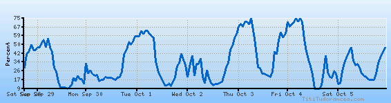
Temperature variation graph for the last seven days

Humidity Variation Graph
Wind speed

Weather Station: Sheridan, Sheridan County Airport (latitude 44-46-10N, longitude 106-58-08W)
Local Time:
Sheridan City/County is in the "America/Denver" timezone.
The "America/Denver" timezone uses a Standard Time (ST) / Daylight Saving Time (DST) alternation scheme, and it currently is in ST (since Sunday, 3 November 2024, 01:00 AM local time). During ST, the timezone abbreviation is MST and the offset to Universal Time (UTC, GMT or Zulu) is -7:00 hours.
Sheridan City/County will exit standard time (entering DST) on Sunday, 9 March 2025, at 02:00 AM local time, when clocks will be turned forward 1 hour to Sunday, 9 March 2025, 03:00 AM local daylight time. During DST, the timezone abbreviation is MDT and the offset to UTC will be -6:00 hours.
Weather and Temperature in Wyoming