| World |
When things get dusty, expect rainfall changes
Researchers with support from the U.S. National Science Foundation recently discovered that Saharan dust is the number one variable linked to tropical cyclone rainfall.

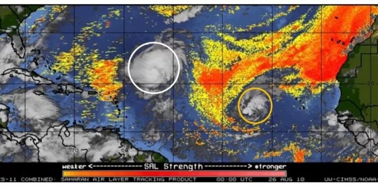
Geostationary Operational Environmental Satellite (GOES)-11 Saharan Air Layer product on 00 UTC 26 August 2010. The orange shading represents a dry and potentially dusty environment introduced by Saharan Air Layer. White and orange circles represent Hurricanes Dannielle and Earl, respectively. Credit: Yuan Wang, Stanford University
Trade winds lift the dust over the Saharan desert and across the Atlantic Ocean. The tiny particles are the predominant aerosol type during summer and early fall over the tropical Atlantic, forming the seed around which a cloud grows.
"Traditionally, people focused on sea surface temperature and moisture in the atmosphere to help predict tropical cyclone rainfall," said Laiyin Zhu, a professor at Western Michigan University and the first author of the study.
"Our study brings more attention to aerosols – specifically, Saharan dust."
The multi-institute research team used a machine learning model that leveraged 19 years of satellite data on rainfall to predict tropical cyclone rainfall for individual storms.
They found that high dust density over the Atlantic Ocean suppresses tropical cyclone rainfall by blocking energy from sunlight. In comparison, a moderate dust density in pristine conditions enhances the tropical cyclone rainfall, likely by providing more ice nuclei to form clouds.
This finding will help evaluate climate models, which are limited to extreme weather events like tropical cyclones.
"With improved climate models, we can better understand the human impacts on the relationship between dust and cyclones," said Professor Yuan Wang at Stanford University, the senior author of the paper and a co-principal investigator of the NSF project. "Although machine learning helped us see the correlation, it cannot tease out causation."
YOU MAY ALSO LIKE


