| Weather / Wisconsin Weather Temperature |
Weather in Watertown, Wisconsin
Current Conditions (Thursday, March 27, 2025 at 06:35 America/Chicago time)
Temperature: 37°F (3°C) |
Forecast Overview
Thu Mar 27 
52°F 37°F 11°C 3°C Chance of light rain in the morning.
detailsFri Mar 28 
72°F 45°F 22°C 7°C Chance of rain at various times.
detailsSat Mar 29 
63°F 34°F 17°C 1°C Chance of rain at various times.
detailsSun Mar 30 
34°F 25°F 1°C -4°C Chance of rain and freezing rain in the morning. Chance of snow after 1 pm.
detailsMon Mar 31 
30°F 14°F -1°C -10°C Overcast skies.
detailsTue Apr 1 
34°F 14°F 1°C -10°C Chance of rain late at night. Chance of snow in the afternoon and in the evening.
detailsWed Apr 2 
43°F 32°F 6°C 0°C Chance of rain in the morning.
detailsThu Apr 3 
52°F 28°F 11°C -2°C Mostly cloudy skies.
detailsFri Apr 4 72°F 41°F 22°C 5°C Chance of rain in the morning.
detailsSat Apr 5 
77°F 50°F 25°C 10°C Chance of rain in the afternoon.
detailsSun Apr 6 
59°F 46°F 15°C 8°C Chance of light rain late at night.
detailsMon Apr 7 
46°F 34°F 8°C 1°C Chance of light snow in the morning and in the afternoon.
detailsTue Apr 8 48°F 28°F 9°C -2°C More clouds than sun.
detailsWed Apr 9 61°F 39°F 16°C 4°C Chance of rain before sunrise.
details
Detailed Forecast
| Thursday, March 27 | sunrise: 06:47 sunset: 19:14 |
| Low around 38°F (3°C), high around 52°F (11°C). Chance of light rain early in the morning, between 4 am and 10 am. Estimated precipitation: 0.02 in (0.625 mm). Overcast skies. Wind: 10 mph (16 km/h). |
| Time | Skies | Conditions | Temp | Wind | Humidity | Soil Moisture |
| 01:00 04:00 | Overcast. | 38°F (3°C) | 7 mph (11 km/h) | 74% | 0.301% | |
| 04:00 07:00 | Chance of light rain. Precipitation: 0 in (0.0625 mm). | 40°F (4°C) | 8 mph (12 km/h) | 76% | 0.302% | |
| 07:00 10:00 | Chance of light rain. Precipitation: 0.02 in (0.5 mm). | 41°F (5°C) | 5 mph (8 km/h) | 87% | 0.306% | |
| 10:00 13:00 | Overcast. | 48°F (9°C) | 4 mph (6 km/h) | 76% | 0.304% | |
| 13:00 16:00 | Overcast. Precipitation: 0 in (0.0625 mm). | 52°F (11°C) | 7 mph (11 km/h) | 62% | 0.303% | |
| 16:00 19:00 | Overcast. | 48°F (9°C) | 6 mph (10 km/h) | 75% | 0.303% | |
| 19:00 22:00 | Partly cloudy. | 42°F (6°C) | 9 mph (14 km/h) | 90% | 0.303% | |
| 22:00 01:00 | Overcast. | 44°F (7°C) | 10 mph (16 km/h) | 88% | 0.303% |
| Friday, March 28 | sunrise: 06:46 sunset: 19:15 |
| Low around 44°F (7°C), high around 71°F (22°C). Chance of rain early in the morning (until 10 am) and in the evening (after 7 pm). The precipitation may fall as scattered showers of varying intensity. Estimated precipitation: 0.23 in (5.8125 mm). Mostly cloudy skies. Wind: 26 mph (41 km/h). |
| Time | Skies | Conditions | Temp | Wind | Humidity | Soil Moisture |
| 01:00 04:00 | Chance of light rain. Precipitation: 0.01 in (0.1875 mm). | 44°F (7°C) | 9 mph (14 km/h) | 94% | 0.304% | |
| 04:00 07:00 | Chance of light rain. Precipitation: 0.04 in (0.9375 mm). | 47°F (8°C) | 10 mph (15 km/h) | 98% | 0.311% | |
| 07:00 10:00 | Chance of scattered rain showers. Precipitation: 0.08 in (1.9375 mm). | 51°F (10°C) | 8 mph (14 km/h) | 99% | 0.321% | |
| 10:00 13:00 | Mostly cloudy. Precipitation: 0 in (0.125 mm). | 60°F (16°C) | 13 mph (20 km/h) | 87% | 0.315% | |
| 13:00 16:00 | Mostly sunny, with a few passing clouds. | 70°F (21°C) | 20 mph (32 km/h) | 63% | 0.31% | |
| 16:00 19:00 | Sunny. | 65°F (19°C) | 22 mph (35 km/h) | 72% | 0.308% | |
| 19:00 22:00 | Chance of light rain. Precipitation: 0 in (0.125 mm). | 65°F (18°C) | 26 mph (41 km/h) | 74% | 0.307% | |
| 22:00 01:00 | Chance of scattered rain showers. Precipitation: 0.1 in (2.5 mm). | 62°F (16°C) | 25 mph (40 km/h) | 83% | 0.323% |
| Saturday, March 29 | sunrise: 06:44 sunset: 19:16 |
| Low around 34°F (1°C), high around 62°F (17°C). Chance of rain between 1 am and 4 am and from 1 pm till 1 am. Estimated precipitation: 0.17 in (4.4375 mm). Overcast skies. Wind: 15 mph (25 km/h). |
| Time | Skies | Conditions | Temp | Wind | Humidity | Soil Moisture |
| 01:00 04:00 | Chance of light rain. Precipitation: 0.01 in (0.375 mm). | 58°F (15°C) | 15 mph (25 km/h) | 88% | 0.318% | |
| 04:00 07:00 | Overcast. Precipitation: 0.01 in (0.25 mm). | 49°F (9°C) | 10 mph (16 km/h) | 84% | 0.316% | |
| 07:00 10:00 | Overcast. Precipitation: 0 in (0.0625 mm). | 45°F (7°C) | 12 mph (19 km/h) | 85% | 0.314% | |
| 10:00 13:00 | Overcast. Precipitation: 0 in (0.0625 mm). | 42°F (6°C) | 11 mph (17 km/h) | 77% | 0.312% | |
| 13:00 16:00 | Chance of rain. Precipitation: 0.05 in (1.1875 mm). | 38°F (3°C) | 12 mph (20 km/h) | 87% | 0.318% | |
| 16:00 19:00 | Chance of rain. Precipitation: 0.05 in (1.375 mm). | 35°F (1°C) | 14 mph (22 km/h) | 88% | 0.322% | |
| 19:00 22:00 | Chance of light rain. Precipitation: 0.02 in (0.5 mm). | 34°F (1°C) | 15 mph (24 km/h) | 88% | 0.319% | |
| 22:00 01:00 | Chance of light rain. Precipitation: 0.02 in (0.625 mm). | 34°F (1°C) | 13 mph (21 km/h) | 94% | 0.32% |
| Sunday, March 30 | sunrise: 06:42 sunset: 19:17 |
| Low around 24°F (-4°C), high around 34°F (1°C). Chance of rain early in the morning (until 10 am). Chance of snow during the afternoon and evening (between 1 pm and 10 pm). Chance of freezing rain in the morning (between 10 am and 1 pm). Estimated precipitation: 0.9 in (22.75 mm). Overcast skies. Wind: 19 mph (31 km/h). |
| Time | Skies | Conditions | Temp | Wind | Humidity | Soil Moisture |
| 01:00 04:00 | Chance of rain. Precipitation: 0.07 in (1.8125 mm). | 34°F (1°C) | 15 mph (25 km/h) | 95% | 0.323% | |
| 04:00 07:00 | Chance of light rain. Precipitation: 0.01 in (0.3125 mm). | 33°F (1°C) | 16 mph (25 km/h) | 94% | 0.321% | |
| 07:00 10:00 | Chance of rain. Precipitation: 0.21 in (5.375 mm). | 32°F (0°C) | 13 mph (21 km/h) | 99% | 0.327% | |
| 10:00 13:00 | Possibly freezing rain leading to formation of glaze ice. Precipitation: 0.15 in (3.6875 mm). | 32°F (-0°C) | 18 mph (30 km/h) | 94% | 0.325% | |
| 13:00 16:00 | Chance of snow. Precipitation: 0.18 in (4.5625 mm). | 29°F (-1°C) | 18 mph (29 km/h) | 95% | 0.324% | |
| 16:00 19:00 | Chance of snow. Precipitation: 0.21 in (5.25 mm). | 29°F (-1°C) | 19 mph (31 km/h) | 95% | 0.322% | |
| 19:00 22:00 | Chance of snow. Precipitation: 0.06 in (1.5625 mm). | 28°F (-2°C) | 18 mph (29 km/h) | 95% | 0.32% | |
| 22:00 01:00 | Overcast. Precipitation: 0.01 in (0.1875 mm). | 24°F (-4°C) | 15 mph (25 km/h) | 92% | 0.319% |
| Monday, March 31 | sunrise: 06:40 sunset: 19:18 |
| Low around 13°F (-10°C), high around 31°F (-1°C). Estimated precipitation: 0 in (0.0625 mm). Overcast skies. Wind: 14 mph (22 km/h). |
| Time | Skies | Conditions | Temp | Wind | Humidity | Soil Moisture |
| 01:00 04:00 | Overcast. | 20°F (-6°C) | 14 mph (22 km/h) | 91% | 0.318% | |
| 04:00 07:00 | Overcast. | 19°F (-7°C) | 12 mph (19 km/h) | 93% | 0.318% | |
| 07:00 10:00 | Overcast. | 25°F (-4°C) | 14 mph (22 km/h) | 86% | 0.317% | |
| 10:00 13:00 | Overcast. Precipitation: 0 in (0.0625 mm). | 30°F (-1°C) | 11 mph (18 km/h) | 80% | 0.319% | |
| 13:00 16:00 | Overcast. | 31°F (-1°C) | 11 mph (18 km/h) | 78% | 0.325% | |
| 16:00 19:00 | Overcast. | 25°F (-4°C) | 5 mph (8 km/h) | 90% | 0.324% | |
| 19:00 22:00 | Clear. | 15°F (-9°C) | 4 mph (7 km/h) | 96% | 0.323% | |
| 22:00 01:00 | Overcast. | 14°F (-10°C) | 4 mph (7 km/h) | 96% | 0.322% |
| Tuesday, April 1 | sunrise: 06:39 sunset: 19:19 |
| Low around 14°F (-10°C), high around 34°F (1°C). Chance of rain late at night (after 10 pm). Chance of snow late in the afternoon and in the evening (between 4 pm and 10 pm). Estimated precipitation: 0.13 in (3.375 mm). Overcast skies. Wind: 16 mph (25 km/h). |
| Time | Skies | Conditions | Temp | Wind | Humidity | Soil Moisture |
| 01:00 04:00 | Overcast. | 19°F (-7°C) | 5 mph (7 km/h) | 95% | 0.322% | |
| 04:00 07:00 | More sun than clouds. | 20°F (-7°C) | 6 mph (10 km/h) | 93% | 0.323% | |
| 07:00 10:00 | Overcast. | 30°F (-1°C) | 12 mph (19 km/h) | 82% | 0.323% | |
| 10:00 13:00 | Overcast. | 33°F (1°C) | 10 mph (16 km/h) | 96% | 0.347% | |
| 13:00 16:00 | Overcast. | 33°F (1°C) | 13 mph (21 km/h) | 86% | 0.371% | |
| 16:00 19:00 | Chance of light snow. Precipitation: 0.03 in (0.75 mm). | 29°F (-2°C) | 11 mph (18 km/h) | 95% | 0.368% | |
| 19:00 22:00 | Chance of snow. Precipitation: 0.08 in (2.0625 mm). | 31°F (-1°C) | 12 mph (19 km/h) | 95% | 0.365% | |
| 22:00 01:00 | Chance of light rain. Precipitation: 0.02 in (0.5625 mm). | 34°F (1°C) | 16 mph (25 km/h) | 91% | 0.365% |
| Wednesday, April 2 | sunrise: 06:37 sunset: 19:21 |
| Low around 32°F (0°C), high around 43°F (6°C). Chance of rain in the morning (between 10 am and 1 pm). Estimated precipitation: 0.13 in (3.1875 mm). Mostly cloudy skies. Wind: 20 mph (31 km/h). |
| Time | Skies | Conditions | Temp | Wind | Humidity | Soil Moisture |
| 01:00 04:00 | Overcast. Precipitation: 0 in (0.0625 mm). | 35°F (2°C) | 17 mph (28 km/h) | 90% | 0.372% | |
| 04:00 07:00 | Overcast. Precipitation: 0.12 in (2.9375 mm). | 37°F (3°C) | 15 mph (25 km/h) | 96% | 0.411% | |
| 07:00 10:00 | Overcast. | 42°F (6°C) | 15 mph (24 km/h) | 99% | 0.428% | |
| 10:00 13:00 | Chance of light rain. Precipitation: 0 in (0.0625 mm). | 42°F (5°C) | 15 mph (24 km/h) | 94% | 0.427% | |
| 13:00 16:00 | Overcast. Precipitation: 0 in (0.125 mm). | 38°F (3°C) | 20 mph (31 km/h) | 92% | 0.394% | |
| 16:00 19:00 | Overcast. | 36°F (2°C) | 19 mph (31 km/h) | 93% | 0.372% | |
| 19:00 22:00 | Overcast. | 36°F (2°C) | 17 mph (27 km/h) | 84% | 0.359% | |
| 22:00 01:00 | Clear. | 32°F (0°C) | 12 mph (20 km/h) | 91% | 0.353% |
| Thursday, April 3 | sunrise: 06:35 sunset: 19:22 |
| Low around 29°F (-2°C), high around 52°F (11°C). Estimated precipitation: 0 in (0.125 mm). Mostly cloudy skies. Wind: 15 mph (24 km/h). |
| Time | Skies | Conditions | Temp | Wind | Humidity | Soil Moisture |
| 01:00 04:00 | Clear. | 31°F (-1°C) | 9 mph (14 km/h) | 94% | 0.349% | |
| 04:00 07:00 | Overcast. | 29°F (-2°C) | 5 mph (8 km/h) | 95% | 0.348% | |
| 07:00 10:00 | Sunny. | 38°F (3°C) | 5 mph (8 km/h) | 79% | 0.347% | |
| 10:00 13:00 | Sunny. | 46°F (8°C) | 2 mph (3 km/h) | 64% | 0.343% | |
| 13:00 16:00 | Mostly cloudy. | 52°F (11°C) | 6 mph (10 km/h) | 56% | 0.339% | |
| 16:00 19:00 | Overcast. | 45°F (7°C) | 14 mph (23 km/h) | 77% | 0.337% | |
| 19:00 22:00 | Overcast. | 37°F (3°C) | 12 mph (20 km/h) | 82% | 0.335% | |
| 22:00 01:00 | Overcast. Precipitation: 0 in (0.125 mm). | 41°F (5°C) | 15 mph (24 km/h) | 76% | 0.334% |
| Friday, April 4 | sunrise: 06:33 sunset: 19:23 |
| Low around 41°F (5°C), high around 72°F (22°C). Chance of rain all morning (between 4 am and 1 pm). The precipitation may fall as scattered showers of varying intensity. Estimated precipitation: 0.78 in (19.875 mm). Mostly cloudy skies. Wind: 20 mph (31 km/h). |
| Time | Skies | Conditions | Temp | Wind | Humidity | Soil Moisture |
| 01:00 04:00 | Overcast. Precipitation: 0.02 in (0.4375 mm). | 45°F (7°C) | 20 mph (31 km/h) | 76% | 0.334% | |
| 04:00 07:00 | Chance of rain. Precipitation: 0.35 in (9 mm). | 46°F (8°C) | 17 mph (28 km/h) | 94% | 0.384% | |
| 07:00 10:00 | Chance of scattered rain showers. Precipitation: 0.28 in (7.1875 mm). | 48°F (9°C) | 18 mph (30 km/h) | 97% | 0.37% | |
| 10:00 13:00 | Chance of rain. Precipitation: 0.05 in (1.25 mm). | 51°F (11°C) | 17 mph (27 km/h) | 98% | 0.361% | |
| 13:00 16:00 | More sun than clouds. Precipitation: 0.06 in (1.625 mm). | 67°F (19°C) | 16 mph (26 km/h) | 88% | 0.362% | |
| 16:00 19:00 | Sunny. Precipitation: 0.01 in (0.375 mm). | 64°F (18°C) | 12 mph (19 km/h) | 78% | 0.353% | |
| 19:00 22:00 | Clear. | 56°F (14°C) | 7 mph (11 km/h) | 88% | 0.349% | |
| 22:00 01:00 | Overcast. | 53°F (12°C) | 5 mph (8 km/h) | 75% | 0.346% |
| Saturday, April 5 | sunrise: 06:31 sunset: 19:24 |
| Low around 49°F (10°C), high around 76°F (25°C). Chance of rain late in the afternoon (between 4 pm and 7 pm). The precipitation may fall as scattered showers of varying intensity. Estimated precipitation: 0.19 in (4.8125 mm). Partly cloudy skies. Wind: 21 mph (34 km/h). |
| Time | Skies | Conditions | Temp | Wind | Humidity | Soil Moisture |
| 01:00 04:00 | Clear. | 51°F (10°C) | 3 mph (5 km/h) | 72% | 0.344% | |
| 04:00 07:00 | Sunny. | 50°F (10°C) | 8 mph (14 km/h) | 76% | 0.342% | |
| 07:00 10:00 | Sunny. | 64°F (18°C) | 13 mph (21 km/h) | 65% | 0.339% | |
| 10:00 13:00 | Partly cloudy. Precipitation: 0 in (0.0625 mm). | 74°F (24°C) | 18 mph (29 km/h) | 66% | 0.334% | |
| 13:00 16:00 | Overcast. Precipitation: 0 in (0.125 mm). | 72°F (22°C) | 16 mph (26 km/h) | 76% | 0.332% | |
| 16:00 19:00 | Chance of scattered rain showers. Precipitation: 0.05 in (1.1875 mm). | 69°F (21°C) | 21 mph (34 km/h) | 79% | 0.338% | |
| 19:00 22:00 | Overcast. Precipitation: 0.12 in (2.9375 mm). | 64°F (18°C) | 19 mph (31 km/h) | 85% | 0.349% | |
| 22:00 01:00 | Overcast. Precipitation: 0.02 in (0.5 mm). | 59°F (15°C) | 14 mph (22 km/h) | 86% | 0.343% |
| Sunday, April 6 | sunrise: 06:30 sunset: 19:25 |
| Low around 46°F (8°C), high around 59°F (15°C). Chance of light rain late at night (after 10 pm). Estimated precipitation: 0.02 in (0.5 mm). Mostly cloudy skies. Wind: 12 mph (19 km/h). |
| Time | Skies | Conditions | Temp | Wind | Humidity | Soil Moisture |
| 01:00 04:00 | Partly cloudy. | 50°F (10°C) | 8 mph (13 km/h) | 82% | 0.339% | |
| 04:00 07:00 | Overcast. | 46°F (8°C) | 8 mph (13 km/h) | 78% | 0.338% | |
| 07:00 10:00 | Times of sun and clouds. | 54°F (12°C) | 12 mph (19 km/h) | 55% | 0.334% | |
| 10:00 13:00 | Overcast. | 58°F (14°C) | 9 mph (14 km/h) | 48% | 0.33% | |
| 13:00 16:00 | Overcast. Precipitation: 0.01 in (0.1875 mm). | 57°F (14°C) | 3 mph (5 km/h) | 48% | 0.329% | |
| 16:00 19:00 | Overcast. Precipitation: 0 in (0.125 mm). | 53°F (12°C) | 3 mph (5 km/h) | 63% | 0.329% | |
| 19:00 22:00 | Partly cloudy. Precipitation: 0 in (0.0625 mm). | 49°F (9°C) | 8 mph (13 km/h) | 69% | 0.329% | |
| 22:00 01:00 | Chance of light rain. Precipitation: 0 in (0.125 mm). | 47°F (9°C) | 11 mph (17 km/h) | 72% | 0.33% |
| Monday, April 7 | sunrise: 06:28 sunset: 19:26 |
| Low around 33°F (1°C), high around 47°F (8°C). Chance of light snow in the morning (between 7 am and 10 am) and in the afternoon (between 1 pm and 4 pm). Estimated precipitation: 0.02 in (0.4375 mm). Considerable cloudiness. Wind: 23 mph (36 km/h). |
| Time | Skies | Conditions | Temp | Wind | Humidity | Soil Moisture |
| 01:00 04:00 | Clear. | 42°F (6°C) | 12 mph (19 km/h) | 83% | 0.329% | |
| 04:00 07:00 | Overcast. | 39°F (4°C) | 15 mph (24 km/h) | 74% | 0.328% | |
| 07:00 10:00 | Chance of light snow. Precipitation: 0.01 in (0.1875 mm). | 42°F (5°C) | 21 mph (34 km/h) | 58% | 0.327% | |
| 10:00 13:00 | Overcast. Precipitation: 0 in (0.0625 mm). | 42°F (6°C) | 19 mph (31 km/h) | 57% | 0.324% | |
| 13:00 16:00 | Chance of light snow. Precipitation: 0 in (0.125 mm). | 43°F (6°C) | 23 mph (36 km/h) | 54% | 0.322% | |
| 16:00 19:00 | Considerable cloudiness. Precipitation: 0 in (0.0625 mm). | 39°F (4°C) | 17 mph (27 km/h) | 62% | 0.322% | |
| 19:00 22:00 | Clear. | 35°F (2°C) | 14 mph (23 km/h) | 67% | 0.322% | |
| 22:00 01:00 | Clear. | 33°F (1°C) | 12 mph (19 km/h) | 70% | 0.322% |
| Tuesday, April 8 | sunrise: 06:26 sunset: 19:28 |
| Low around 29°F (-2°C), high around 48°F (9°C). More clouds than sun. Wind: 13 mph (20 km/h). |
| Time | Skies | Conditions | Temp | Wind | Humidity | Soil Moisture |
| 01:00 04:00 | Clear. | 30°F (-1°C) | 9 mph (15 km/h) | 76% | 0.322% | |
| 04:00 07:00 | Sunny. | 29°F (-2°C) | 9 mph (14 km/h) | 76% | 0.321% | |
| 07:00 10:00 | Sunny. | 38°F (3°C) | 13 mph (20 km/h) | 51% | 0.32% | |
| 10:00 13:00 | Sunny. | 44°F (7°C) | 12 mph (20 km/h) | 40% | 0.315% | |
| 13:00 16:00 | Overcast. | 48°F (9°C) | 11 mph (17 km/h) | 37% | 0.313% | |
| 16:00 19:00 | Overcast. | 43°F (6°C) | 4 mph (7 km/h) | 56% | 0.314% | |
| 19:00 22:00 | Mostly cloudy. | 39°F (4°C) | 4 mph (7 km/h) | 59% | 0.316% | |
| 22:00 01:00 | Overcast. | 38°F (4°C) | 7 mph (11 km/h) | 67% | 0.316% |
| Wednesday, April 9 | sunrise: 06:25 sunset: 19:29 |
| Low around 39°F (4°C), high around 61°F (16°C). Chance of rain between 1 am and 4 am. Estimated precipitation: 0.09 in (2.3125 mm). Mostly cloudy skies. Wind: 16 mph (26 km/h). |
| Time | Skies | Conditions | Temp | Wind | Humidity | Soil Moisture |
| 01:00 04:00 | Chance of rain. Precipitation: 0.06 in (1.4375 mm). | 39°F (4°C) | 9 mph (14 km/h) | 84% | 0.323% | |
| 04:00 07:00 | Overcast. Precipitation: 0.03 in (0.6875 mm). | 41°F (5°C) | 15 mph (24 km/h) | 80% | 0.324% | |
| 07:00 10:00 | Overcast. | 50°F (10°C) | 14 mph (23 km/h) | 69% | 0.321% | |
| 10:00 13:00 | Overcast. | 58°F (14°C) | 16 mph (26 km/h) | 61% | 0.317% | |
| 13:00 16:00 | Overcast. | 59°F (15°C) | 14 mph (22 km/h) | 66% | 0.315% | |
| 16:00 19:00 | Overcast. Precipitation: 0 in (0.0625 mm). | 59°F (15°C) | 9 mph (15 km/h) | 71% | 0.316% | |
| 19:00 22:00 | Overcast. | 57°F (14°C) | 9 mph (14 km/h) | 78% | 0.317% | |
| 22:00 01:00 | Clear. Precipitation: 0 in (0.125 mm). | 55°F (13°C) | 5 mph (8 km/h) | 87% | 0.318% |
Climate Chart
Places with a similar climate: Janesville / Rock County (WI), Monroe (WI), Freeport (IL), Burlington (WI), Madison, Dane County (WI), Prairie Du Chien (WI), Aurora (IL), Boscobel (WI), Kenosha (WI), Waukesha City/County (WI), Lone Rock (WI), Vinton (IA), Winona (MN), De Kalb (IL), Fond Du Lac County (WI), Rockford (IL), West Bend (WI), Milwaukee / Timmerman (WI), Algona (IA), Clinton (IA), Boone (IA), Alma, Gratiot (MI), Detroit (MI), Orange City (IA), Juneau, Dodge County (WI).
Temperature variation graph for the last seven days

Humidity Variation Graph

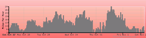
Wind speed
Weather Station: Watertown (latitude 43-10N, longitude 088-43W)
Local Time:
Watertown is in the "America/Chicago" timezone.
The "America/Chicago" timezone uses a Standard Time (ST) / Daylight Saving Time (DST) alternation scheme, and it currently is in DST (since Sunday, 9 March 2025, 03:00 AM local time). During DST, the timezone abbreviation is CDT and the offset to Universal Time (UTC, GMT or Zulu) is -5:00 hours.
Watertown will exit DST (returning to standard time) on Sunday, 2 November 2025, at 02:00 AM local time, when clocks will be turned backward 1 hour to Sunday, 2 November 2025, 01:00 AM local standard time. During ST, the timezone abbreviation is CST and the offset to UTC will be -6:00 hours.
Weather and Temperature in Wisconsin